In the middle of Kornhamnstorg, one can see the statue called " Bagspannaren" (Bow Bender)by Christian Eriksson. The sculpture shows a young man that ranges his arm bristle. The statue is created in memory of Engelbrekts
November 25, 2010
Kornhamstorg, the "Grain Harbour Square
In the middle of Kornhamnstorg, one can see the statue called " Bagspannaren" (Bow Bender)by Christian Eriksson. The sculpture shows a young man that ranges his arm bristle. The statue is created in memory of Engelbrekts
November 24, 2010
Järntorget (The Iron Square)
Järntorget dates back to around 1300 and remained the city's most important trade centre for centuries, constantly busy and crowded, scents and noise intermixing while goods were transported from shore to shore across the square and up and down the attics of the surrounding buildings.
In the early 17th century, numerous taverns were located around the square. The city's official scales were relocated to Södermalm in 1662 and the entire area around the square underwent a transformation as wealthy people had taller and more prestigious buildings erected over merged lots.
The development was actively supported by the king who wanted the capital to be more representative, the medieval buildings thus disappearing together with medieval alleys. The development was further promoted by the construction of Södra Bankhuset , the national bank building on number 84 in 1680. The building remained the headquarters of the Bank of Sweden until the early 20th century.
The well centred on the square is made of cast iron, modeled to a british prototype, and was a donation from the National Bank 1829.
In front of the bank building is one of the famous sights, the statue of Evert Taube, which was inaugurated in 1985. The popular troubadour and composer in beret and sun-glasses, with music sheets in his hands.
November 23, 2010
RINKEBY
November 22, 2010
STOCKHOLM CITY LIBRARY
Opened in 1928, built from a investigation project with a budget of two million SEK that in year 1918 was given to architect Gunnar Asplund who spent a few years researching in Europe and US. Stockholm City library became the major work for Gunnar Asplund and a sign for him as a front figure in Swedish Grace.
The site is Sveavägen 73 in Stockholm, at the edge of an ridge that divides the districts Norrmalm and Östermalm. Neighbouring buildings are from late 19th century and in an area where the new university was to be placed. In the corner where the major street Odengatan meets Sveavägen, as it stretches from Stockholm northern entrance and into the city centre.
The building is a simple composition of a cube and a tube. The tube is rising in the centre and creates a monumental appearance. So those also the broad stair towards the framed entrance. Asplunds first classical design had a cupola instead of the tube. The final outcome had more purified design according to its function and geometry. Only a few ornaments where allowed like Ivar Johanssons Egyptian inspired relief in the entrance, and a fries with different foreign writing symbols on the outside around the building. Gunnar Asplund is most famous for this Swedish Grace building, but this final outcome is also in line with his movement from classical design towards his modernistic design as he used later from the 1930’s
The function of the library is of a single open space containing 700 000 books , (the tube), surrounded by study rooms and light gardens. Introducing in Sweden an US system of public bookshelves where the costumers could pick a book without assistance. Renovations has made the library accessible with wheelchair and lifts are installed in-between the big rooms.
Author and photografer: Åke Hjalmarsson Internet sources: www.wikipedia.com Written sources:Att bygga ett land -1900-talets svenska arkitektur, Claes Caldenby, Arkitekturmuseet/byggforskningsrådet 1998 ISBN 91-540-5813-9
Söderköping
What’s more, there is also a route for bycicles along the canal,strechs about 100 km,provides a great opportunity to experiance the views in virous ways.
The hills located on the otherside of the canal is also a perfect recreational place for climbing and other outdoor activities.views from the hill are quite fascinating.
Source:
Tegnérlunden, Stockholm
Tegnerlunden is a park on the border between the districts and Norrmalm Vasastaden in central Stockholm, situated between Queen Street and Upland Way.
At Tegnerlunden are including Individual School at Tegnerlunden 5 and Swedenborg Memory Church at Tegnerlunden 7.
The park was originally created in the 1890s, when the windmills had been demolished. When was the least of all Stockholm parks. There were flower discounts and lawns were not accessible. In the early 1940s omdanades Tegnerlunden sweeping through Stadstradgardsmastaren Holger Bloms proposal together with Erik Glemme. An artificial Brook flow performs pastures, stop at the small water mirrors and a small stone bridge and finally emerge valvs in and irregularly shaped padding dust.
Norrkoping industrial heritage
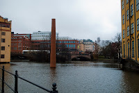
Norrköping was the first stop during our trip to Stockholm. Norrköping is located in Östergötland province in the east of Sweden. It is only about 135 kilometers from the capital Stockholm. The river Strömmen flows through the city. Because of this rich water resource; Norrköping is one of the earliest cities in Sweden to develop industries and is especially well-known in Scandinavia for its textile industry.
The industry here started in the 17th century. Because of the utilization of water power from Strömmen, the factories were built along the river.
After the Second World War, with the influx of cheap imported textiles from Japan and other countries, the textile industry in Norrköping faced crises. Factories closed one after another during the next years and in 1970 the closure of last large textile company declared the end of textile period in Norrköping, leaving the silent factories. The machines were either sold or abandoned.(Sven Tynelius and John Lovén,1982:3) During the idle period, the Council and the trade in Norrköping discussed the fate of the industrial buildings. At last, they decided to preserve them and use them for different purposes.
In 1971, a historical and cultural inventory of the entire city was started by the municipality.
Today, as result of the step by step transformation, Norrköping is revived as a center of culture and education. It consists of museums, a concert and congress hall, a university, Science Parks, shops and café bars.
There were so many factories in the center of Norrköping that the renewal could not be put in one model, but instead, the models were diversification. The thematic museum model, the shopping mall model, art zone model and community model were all adopted.
Aside from the actual buildings, chimneys and sculptures can also record history. There are 13 falls which measure 300 meters long and 18 meters high. Today, the waterfalls are not only used for water power, but also as a characteristic landscape for the Strömmen area.
Slussen-The lock
In the 1930’s, the old lock connecting Gamla Stan and Södermalm was replaced by a traffic solution primarily designed for cars. In many ways it was an ingenious solution, integrating underground, pedestrian, automobiles and buses in a complex shamrock-shaped traffic system designed by Tage William-Olsson.
Three type of public transportation link is framed along Slussen,
2.bus terminal
3.Saltsjöbanan tramway station serving the eastern parts of Stockholm and its surroundings. Djurgårdsfärjan departs adjacently.
Slussen is an example for ingenious traffic and is in need of better urban planning because there is combination of major road networks and underground networks.
In May 2009, the city of Stockholm announced that the firm of Norman Foster had been selected to create a new master plan of the Slussen area. The design of Foster and Partners features two linked pedestrian bridges and one for traffic. It removes many of the existing roads and creates several new blocks of buildings in proximity to the waterfront.
slussen will be renovated and rebuilt. The new links to stadgsgarden and skeppsbron make the area even more important as a meeting place.
City Planning has identified many issues to investigate further in future work.
• View and space, nature of the place.
• The development 'impact on views
• Number of lanes on the bridge
• Salt Lake Railway terminus
• Main bridge abutments
Efforts to find a solution for Slussens future design is in full swing. The proposal now being developed is structured around key functions - traffic, water and city life.
Construction start is planned for 2012 and the new traffic solution is expected to be completed by 2018.
Watch the animation about the future Slussen in this Video below,
http://www.youtube.com/watch?v=D5XhFoJjFws
Sources From webpage
http://www.stockholm.se
http://en.wikipedia.org/wiki/Slussen
November 21, 2010
Hammarby Sjöstad
Hammarby Sjöstad is located in south of Stockholm. It's a new developing district surrounding Hammarby Lake.The environment of the lake shaped the infrastructure, urban planning and design of the buildings.
Limited building depths, requirement of views, recessed penthouse flats, large balconies, big windows, flat roofs and so on are a few features to reach the aim of focusing on ecology. Traffic and sevices are concentrated along a three-kilometre avenue linking Hammarby Sjöstad together. Parks, quays and walkways in different styles are eco-friendly around Hammarby Sjöstad.
Since Stockholm's bid for the 2004 Olympic Games, the core area of Hammarby Sjöstad was served as an Olympic Village, which focus on ecology and environmental sustainability. People has developed a common eco-cycle model designed to ensure organic recycling throughout Hammarby Sjöstad, known as "The Hammarby Model".
The model shows how energy, waste and water treatment can be integrated. Combustible waste, biofuel from nature, the heat from the treated wastewater and solar energy are converted into district heating and electrictiy. Facilities have been built to deal with water and sewage. As for waste, there are three-level waste management, building-based separating at source, block-based recycling rooms, area-based hazardous waste collection point and automated waste disposal system.
pictures are from google
futher information:
http://www.hammarbysjostad.se, http://www.stockholm.se/hammarbysjostad
Tekniska nämndhuset, Stockholm
Technical Board of the house is a local government building in central Stockholm to address Fleminggatan 4th The building is home to Stockholm Municipality's technical departments, the Development Administration, Sport Management, Real Estate, the Environment, City Planning and Urban Transportation. The Technical Board of the house there are jobs for 1200 officers.
The building
The building has six floors, is built of red brick, and was built between 1962-1965. Architects were Nils Sterner, Carl-Olof Deurell. Office complex is divided into three building cells, which in turn is broken down into parallel facade panels. Entrance Corridor is artistic stoneware decorated with reliefs of the artist and designer Gunnar Larson. Later, some administrations have come to be housed in an adjacent older building, the so-called Separatorhuset, which now included in nämndhuskomplexet.
Operations
The largest section of the Technical Board of the house is the Stockholm City Planning Committee which was formed in 1955 and is subject to City Planning. The office is responsible for detailed development and planning process and deals with building permits and construction notifications. The office is also responsible for the City Survey in Stockholm and review applications for grants for home modifications. City Planning has a large archive that covers beyond the original city of Stockholm also Brännkyrka, parts of Huddersfield, Bromley, Spånga, Bromsten, Profit-sharing and Hässelby. In urban expedition submitted planning application and the public may read and copy include:
Construction Documents and Drawings
Detailed development plans (urban planning)
Building Plans
Site Maps
Historical maps and photographs
Publications